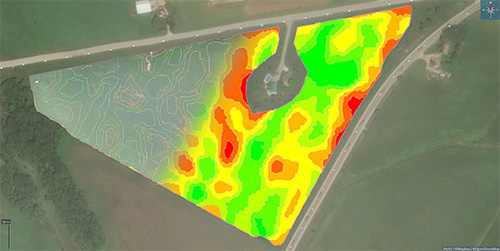
Soil Mapping Technologies
 Modern technologies and newer available soil tests drive a greater understanding of soils and how that impacts productivity and sustainability. The main goal of precision ag is to analyze field variability to map soil potential. Changes in soil texture, structure, organic matter, salinity, water holding capacity and subsoil differences are all factors that can impact yield. To vary fertility, seed, or other inputs across a field, you need accurate soil maps. Precision Ag needs high-resolution maps, starting with building zone, grid or benchmark soil fertility maps. Gain advanced insights into mapping soil potential through other tools, some of which are free, including:
- Soil type maps
- Satellite & aerial imagery
- Elevation/topography maps e.g. those generated by RTK
- Electrical Conductivity Maps
- Gamma Radiation Soil Maps.
Two such tools gaining wider use are electrical conductivity and gamma radiation sensors. Using RTK positioning while collecting sensor data across a field, these tools can provide highly detailed field elevation and soil maps. These tools complement traditional soil testing to provide greater insight into soil variability, and however, they cannot replace traditional soil testing. Before venturing into collecting more data, it is essential to ask yourself how this data can help you better manage and profit from this information.
Electrical Conductivity
Soiltexture has a significant influence on productivity. Electrical conductivity devices are able to map fields for variations in soil texture(sand, clay), salinity, soil organic matter, topsoil depth. Soil is an electrical conductor, and EC devices measure how easily an electrical current passes through the soil. Soil Ec readings are affected by soil moisture, soil texture (sand, silt, clay), porosity, salinity, compaction, organic matter. EC meters allow precise mapping of these soil properties. . EC maps can be a powerful step in defining soil management zones, guiding soil sampling locations, helping in interpreting yield maps, and making crop and soil management decisions. There are two types of ECa sensor equipment used; contact sensors (coulters) -Veris Soil Mapping System (https://bit.ly/3FZbfBE, youtube: https://bit.ly/verisec) and non-contact sensors- Geonics EM38, DualEM. Using RTK GNSS sensors can provide high-density data to map topographic and field variability. Soil texture does not change, so EC mapping is typically a one-time operation with no expiry date. Recognize that soil type maps are still valuable as they provide other information that soil texture maps do not. SwatMap
Gamma-Ray Soil Spectrometry
Gamma-Ray Soil Spectrometer is a non-contact sensor that can provide high-resolution maps of a range of soil properties. The sensor measures the naturally low radiation levels in the topsoil from potassium, uranium and thorium present at different concentrations across fields. The sensor is used with RTK GNSS on a vehicle to generate detailed topography maps, soil texture, soil moisture, and defining zones for soil fertility sampling. One such gamma-ray sensor is the Soil-Optix. Read more about its use Olds College Smart Farming